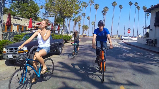
Santa Barbara’s biking culture has boomed over this last decade. The boom could be heavily attributed to the tank-top and sunglass weather that somehow sticks around all 12 months of the year. It could also be a result of the city’s unique terrain, with the mountains and the ocean so close together. Some claim that it is due to the high cost of living which encourages the city’s deep-pocketed residents to enjoy a variety of fancy frames and wheels. Others argue that it’s owed to the cruiser culture which the city’s youth have created via massive group rides. But, anyone who has biked in Santa Barbara will tell you the real reason is the amazing bike routes available to cyclists.
Table of Contents:
Types of Bikes for All Levels of Bike Routes
5 Bike Routes
#1 Beachfront Breeze / 9.3 miles
#2 Downtown to Riviera / 9.1 miles
#3 Goleta the Goodland / 33 miles
#4 The Montecito Mt. & The Hope Ranch Hill / 26 miles
#5 Ride the Ridge / 36 miles
Types of Bikes for All Levels of Bike Routes
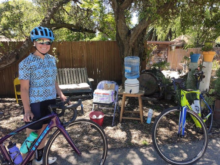
Regardless of the bike you’re riding, there is a Santa Barbara bike route perfect for you. The stunning scenery and bike-friendly infrastructure help form a dreamland for biking. The following bike routes are designed for different types of bikes and riders. These bikes include cruisers, e-bikes, hybrids, and road bikes. This guide will help you choose the right bike route as well as the right bike for you. Before we jump into the bike routes let’s cover the basics for each type of bike.
Cruisers
- Heavier frame, wider tires, designed for comfort and believe it or not “cruising”.
- Simple and straightforward riding experience with 3-7 speeds/gears.
- Typically used for routes with minimal hills and rides ranging from 5 – 15 miles.
Electric Bikes
- Similar frame and tire build as the cruiser with a motor and battery built-in for pedal-assisted riding.
- Fun and exhilarating riding experience that lets you see more in less time. They also turn hills into speed bumps.
- Typically used by the recreational rider hoping to expand their ride to 10-30 miles.
Hybrids
- Commonly mistaken for an ebike, the hybrid is actually a hybrid between a mountain bike and a road bike.
- Lightweight frame, thinner tires, but still comfortable with flat handlebars like a mountain bike.
- Plenty of gears, usually 21-27 speeds, great for quickness and climbing like a road bike.
- Typically used by the avid bike rider looking for speed and fitness on rides ranging 10-40 miles.
Road Bikes
- Higher-end bike that’s very lightweight with a more aggressive geometry.
- Lighter than a hybrid, drop handlebars for aerodynamics, and traditionally nicer components than hybrids or mountain bikes.
- Typically used by experienced cyclists aiming to ride 20-50 miles.
Most of Santa Barbara’s bike routes can be tackled on any of these bikes. But, in order to maximize your bike riding experience, we’ll match up routes with bikes to help you decide.
5 Bike Routes
Below are 5 bike routes in order of difficulty. The first two comprise of routes in downtown Santa Barbara. The final three comprise of longer rides that explore the neighborhoods surrounding Santa Barbara.
#1 Beachfront Breeze
-
- 9.3 Miles
- 150 Feet of Climbing
- 40 – 60 minutes
- Cruiser / Electric Bike
- Difficulty: Easy
Summary

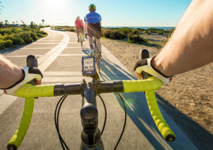
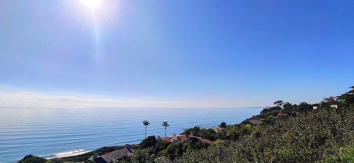
Every great meal starts with a great appetizer that wets the appetite. This ride is the quintessential Santa Barbara appetizer. This bike route is primarily flat with just three brief uphills. This route stretches across the 3 main beaches in Santa Barbara’s downtown and ventures into Montecito’s most popular beach. Of all the bike routes in Santa Barbara no other route is as family-friendly and bike path heavy.
Quick Tip
This ride is 85% bike path (off the road / no cars) and the remaining 15% is the quiet and tame Channel Drive in Montecito.
Part 1: East Beach to Butterfly Beach & back
From the east beach parking lot, you’ll spot the bike path on the mountainside of Cabrillo Blvd directly in front of the waterfront hotels. From there we recommend riding south towards Montecito to start your ride. Your journey will take you along the East Beach Volleyball Nets and the Andree Clark Bird Refuge. As you approach the end of the bird refuge cross over Cabrillo Blvd onto the bike lane of Channel Drive adjacent to the Santa Barbara Cemetery. The bike lane stops a third of a mile down the road where a floral bike path appears with outstanding views of the ocean. As you coast in between vibrant greenery your downhill speed will launch you back onto Channel Drive with intimate views of Butterfly Beach. As the road begins to curve left we recommend turning around and retracing your steps. You could continue up Channel if you’re inclined to explore the boutique downtown of Montecito. If you choose to do so keep in mind that there are a couple of busy intersections that you’ll be sharing with frequent car traffic.
Part 2: East Beach to West Beach, The Harbor, Leadbetter Beach, & back
As you retrace your steps you’ll notice the bike path crosses Cabrillo Blvd and begins a long stretch of riding underneath palm trees along the sand of East Beach. The path leads directly to Stearns Wharf and continues along the sand of West Beach. The path then meanders around the parking lot of the harbor where you can spot an array of beautiful boats. After the harbor parking lot, the path appears to end but make sure you continue through the Leadbetter parking lot as the path continues just past Shoreline Cafe. At the end of the Leadbetter Beach parking lot, the path continues for a half-mile more up to Shoreline Park overlooking the ocean and marina. After taking advantage of the perfect Instagram moment, just retrace your steps down the hill and back into the heart of town.
#2 Downtown to Riviera
-
-
- 9.1 Miles
- 750 Feet of Climbing
- 50 – 70 minutes
- Electric Bike / Hybrid
- Difficulty: Intermediate
-
Summary
Of all the possible bike routes this one is for architecture lovers and city view seekers. This tour of the city starts at the pier and ventures slightly uphill through the backbone of Santa Barbara. It’ll soon take you off the main drag in order to see the historical buildings that reflect the city’s heritage. After climbing up 300 feet the route takes you off the beaten path up another 450 feet into the Riviera. The destination is well worth the workout as you enjoy a breathtaking view from a hidden park on the Riviera.
Quick Tip
This ride has an epic start and finish at the end of the pier, also known as Stearns Wharf. You can actually park your car on the pier for free for 90 minutes giving you plenty of time to complete this bike route.
Part 1: The Pier, Downtown, & Historical Landmarks
Start your ride from the end of the pier and bike straight into town. The pier becomes State Street which is the heart of Santa Barabra’s shopping and nightlife. The street starts with 5 blocks of bike lane before becoming a promenade. Expect a mellow pace as the State Street Promenade is popular among walking pedestrians and fellow cyclists. At E Canon Perdido turn right, on the second block, you’ll get a peek through history to your right and left. On your right, you’ll see the last building from Santa Barbara’s Old ChinaTown and on your left the historic El Presidio.
After enjoying a sip at Handlebar Coffee turn left onto Santa Barbara Street. By your 3rd block up you’ll run into another worthy stop at Santa Barbara’s stunning Courthouse and Sunken Gardens. Continuing straight up Santa Barbara Street you’ll pass the local favorite picnic hangouts of Alameda Park and Alice Keck Memorial Gardens. As you approach Mission Street turn right, and as the street ends into a “T” intersection turn left onto Laguna Street. At the top of Laguna will be the tranquil rose gardens and Historical Mission of Santa Barbara.
Part 2: The Riviera, Franceschi Park, and back to The Pier
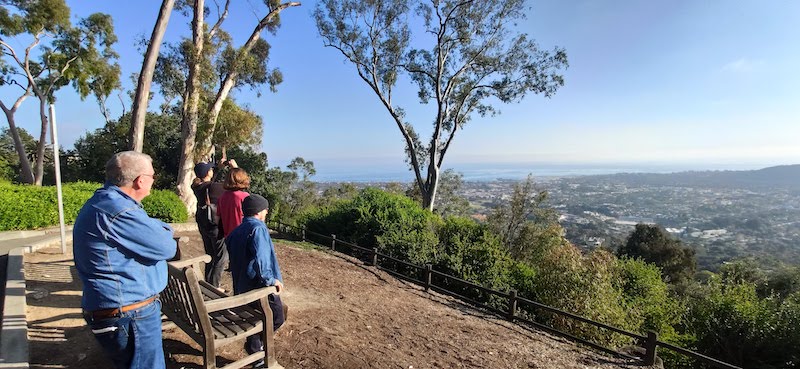
From the front of the Mission continue riding uphill on E Los Olivos Street and at your second opportunity turn right on Mountain Drive. The next mile will be the toughest segment but in less than 10 minutes it will all be worth it. At the funky yield intersection make a hairpin right turn onto Mission Ridge Road. Continue up this calm road for ¾ of a mile until you spot a sign with yellow lettering on your left that says Franceschi Park. At your next opportunity turn left up Franceschi Road and left into the park. At the end of the parking lot rests your reward. Franceschi is a hidden gem home to the best view of the city. After taking a breather and snapping a couple of photos retrace your steps back down to the Mission.
As you ride downhill past the Mission continue straight on E Los Olivos Street through the stop sign at Laguna. After 4 blocks on E Los Olivos, you’ll be reunited with State Street. At State Street turn left and enjoy the well-deserved downhill on State’s bike lane. As you venture back into downtown you’ll notice a few more historical structures such as The Arlington Theatre and The Granada Theatre. After 9 blocks the bike lane ends and the top of the promenade begins. Continue coasting down the promenade all the way back to the ocean where you’ll find yourself back on the pier. To cap off your ride we recommend a sip of Chardonnay and Pinot Noir from the panoramic viewing deck at Deep Sea Wines.
#3 Goleta the Goodland
-
-
-
- 33 Miles
- 1,000 Feet of Climbing
- 2.5 – 3 hours
- Electric Bike / Road Bike / Hybrid
- Difficulty: Intermediate
-
-
Summary
Just beyond the city limits of Santa Barbara is Goleta, known among locals as “The Goodland”. Curious to know why? If you embark on this ride you’ll soon discover just how good the bike routes and views are. This route begins with the Santa Barbara waterfront and extends through the friendly neighborhood of The Mesa. After passing Hendry’s Beach the route winds you through the ritzy real estate of Hope Ranch. The ride then connects with the 5-mile-long Obern Trail. The Obern Trail is a local’s favorite bike path that sneaks behind neighborhoods and spits out at Goleta Beach. The bike path continues up a cliffside into the massive bike trail network on the campus of UCSB. When you’re undoubtedly lost just wander back to the coast and the Obern Trail will bring you home.
Quick Tip
Most published bike routes navigating riders to the Obern Trail or UCSB do not include The Mesa and Hope Ranch. That’s because there are a lot of riders that like the quickest and flattest route that exists. If you prefer exploring the most scenic route and don’t mind a few extra miles and uphill climbs, then you’ll want to keep reading. If that doesn’t sound like you you’re probably reading the wrong blog. Pro tip: the extra time, distance, and uphill won’t only make the ride more scenic, it’ll also mean less car traffic and fewer turns for easier navigation.
Part 1: Santa Barbara’s Northern Oceanfront & The Mesa
Starting from the same east beach parking lot as most of these bike routes you’ll have the choice of bike lane or bike path. If you prefer to be off the street and don’t mind a slower pace you’ll enjoy the Cabrillo Bike Path. If you prefer speed you’ll want the bike lane on Cabrillo Blvd where there aren’t pedestrians and fewer cyclists. Start your journey by heading north towards the pier and harbor. This route is designed for simple navigation, perfect for enjoying the view and avoiding the stress of getting lost. You’ll keep straight for 4 miles as Cabrillo becomes Shoreline, and Shoreline becomes Meigs. After 4 miles of gradual incline turn left on Cliff Drive at the busy intersection of Meigs and Cliff. In a half-mile, you’ll start to pick up serious speed and at the bottom of the hill continue straight through the roundabout.
Part 2: Hope Ranch & Modoc Bike Lane
At this point prepare for an abrupt 150-foot climb over the next half mile. As Cliff Drive plateaus and you approach a stop sign turn left onto Marina Drive. You’ll notice a metal archway signifying your entrance into the beautiful rolling hills of Hope Ranch. For the sake of simplicity through the windy roads of Hope Ranch stay straight through the entire neighborhood. Marina quickly becomes Las Palmas and you’ll fly through the shaded paradise for 3.5 miles you’ll have exited Hope Ranch. As the highway overpass comes into view take 2 left-hand turns onto Modoc Road continuing north towards Goleta. After just 3 minutes of coasting on Modoc’s bike-friendly bike lane, you’ll spot a sign for the Obert Trail on your left at the first and only crosswalk on Modoc.
Part 3: The Obern Trail, Goleta Beach, UCSB trail network, & back
Turn left onto the trail and follow the signs with a green and yellow graphic of a sun and a cyclist. The trail runs onto Nueces Drive and Arroyo Rd for a brief moment before becoming a dedicated bike path. The path is a serene 5 mile stretch without stops all the way through Goleta Beach. As you pass Goleta Beach the path flows along the campus clifftop of the University of California Santa Barbara. When the path runs into Lagoon Road cross over the road and stay straight on the campus bike path. At this point, half the fun is getting lost in the bike path network web of UCSB. If you prefer a plan, the easiest way to see the entire campus is by staying straight or right at each bike path roundabout. This will allow you to see a majority of the campus and will eventually bring you back to Lagoon Road. At which point just retrace your steps on the Obern Trail back to Santa Barbara.
#4 The Montecito Mt. & The Hope Ranch Hill
-
-
-
-
- 26 Miles
- 3,000 Feet of Climbing
- 2.5 – 3 hours
- Electric Bike / Road Bike / Hybrid
- Difficulty: Experienced
-
-
-
Summary
 Say hello to the ultimate Santa Barbara sampler. Quiet roads, spectacular views, amazing homes, this bike ride has it all. Of all the possible bike routes you could take no other route will deliver as many rewarding uphills and beautiful downhills. Prepare for a workout and prepare for that workout to pay off. This bike loop starts by heading south along Santa Barbara’s coastline into Montecito. It takes a direct climb up into the lavish hills of Montecito onto a roller coaster road winding along the mountain. It cuts past the Historical Mission and through town over to the lush neighborhood of Hope Ranch. The finale is a mellow downhill laced with miles of expansive ocean views.
Quick Tip
This ride is equally enjoyable ridden in reverse order. The uphills and downhills invoke awe whether you start with Montecito or Hope Ranch. Whichever direction you choose you’ll get great views. Just be sure you don’t miss the humorous mailbox found at 1600 Mountain Drive.
Part 1: Montecito & Mountain Drive
From Santa Barbara’s waterfront ride south on the Cabrillo Blvd. The start of this ride is identical to part one of the beachfront breeze ride mentioned above. After turning onto Channel Drive and riding along Butterfly beach turn right onto Danielson Road. At your first 4-point intersection turn left onto San Ysidro Road. San Ysidro has smooth bike lane climbing all the way through lower Montecito. At the top of San Ysidro Road turn left onto Mountain Drive. Mountain Drive is included on all of the must-do bike routes ridden by local cyclists in Santa Barbara. The 7.6-mile ride rolls up and down winding left and right with stunning mountainside views. At the funky 5 point intersection stay left and then right at the stop sign along the 192 to continue on Mt. Dr. The slithering downhill eventually ends at E Los Olivos where you’ll turn left into town.
Part 2: Through Town over to Hope Ranch
On E Los Olivos stands Santa Barbara’s most popular tourist attraction – The Historical Mission of Santa Barbara. This stunning structure will be on your right as you coast down E Los Olivos Street. Continue straight cutting through downtown until you find Oak Park Lane, turn right here. After two quick blocks turn left onto W Junipero. At the end of Junipero, you’ll spot a pedestrian bridge over the highway. Take that bridge which will conveniently spit you out onto the bike lane of Modoc Road. Turn right onto Modoc Road and stay on the Modoc Road bike lane for the next 1.7 miles. As soon as you ride underneath the overpass make a snappy left and then right-hand turn and you’ll spot an archway greeting you into the neighborhood of Hope Ranch.
Part 3: Hope Ranch & Sea Ranch
Hope Ranch is a private residential community with shaded streets wildly popular among cyclists. Most Santa Barbara bike routes incorporate Hope Ranch because the car traffic is minimal, the roads are smooth, and the scenic home-viewing is exquisite. Start your Hope Ranch riding by staying straight on Las Palmas Drive. Immediately after passing the golf course and body of water on your left, take a left on Lago Dr. and then your second right turn on Estrella Dr. Estrella Drive is a steady incline of 200 feet over 1 mile. At your first 4-point intersection turn left on Cuervo Ave. This road climbs for another 200 feet before it ends at Campanil Dr. Walk your bike over the road barrier and turn right onto Campanil. Take your next right hand turn down the rapid downhill of Sea Ranch Road. This downhill is fast and epic so be sure to take it slow and enjoy the prodigious view of the pacific ocean. At the bottom of the hill make a quick right and then left turn onto Cliff Drive.
Part 4: Miles of Ocean Views Downhill
Cliff Drive runs along Lover’s Point on your right and quickly moves into a winding downhill. At the bottom of the hill, you’ll pass Hendry’s Beach and continue on Cliff Dr. straight through the roundabout. Atop of your next hill is the Mesa neighborhood on the northwest corner of Santa Barbara. From the busy stoplight of Cliff and Meigs turn right onto Meigs Road. From here on out just stay straight in the bike lane as the ocean breeze and ocean views welcome you back into downtown. Meigs soon turns into Shoreline Drive along Shoreline Park and Shoreline eventually becomes Cabrillo Blvd. These last 4 miles of oceanfront riding are a refreshing reward after tackling the mountains in Montecito and the hills of Hope Ranch.
#5 Ride the Ridge
-
-
-
-
-
- 36 Miles
- 6,700 Feet of Climbing
- 3.5 – 4.5 hours
- Road Bike / Hybrid
- Difficulty: Advanced
-
-
-
-
Summary
 Nothing else north of Los Angeles or south of San Francisco is as epic as this bike ride. While most of our bike routes mentioned can be ridden casually, this ride is for those who desire a challenge. This bike route takes you from ocean to mountain top in under 13 miles while accomplishing 4,200 feet of climbing. This bucket list style route is the ultimate Santa Barbara road bike ride and a must for avid cyclists. This bike route starts off with a mellow warm-up through town and quickly begins to ascend. The 2nd through the 13th mile is where the bulk of the climbing takes place. After scaling the Santa Ynez Mountains you’re rewarded with 7.2 miles of epic views as you roll along the ridgeline. After descending down Painted Cave and Old San Marcos you’ll connect with the Obern Trail for a flat cool down.
Quick Tip
Don’t forget to bring two bottles of water! This ride is as hot as it is long. If you’re in need of a fill-up there is a water spigot near the top of Painted Cave Road. There is also a second water spigot near the end of the descent on Old San Marcos Road. Secondly, plan for varying temperatures. Even though Santa Barbara mornings can be chilly near the ocean, halfway up the mountain the temperature will likely spike. The same goes for the deceivingly sunny days. You might feel comfortable in a short-sleeve climbing up, but a lightweight long sleeve is a good call in order to battle the chilling air that you could face flying downhill.
Part 1: Downtown to Mountain Drive
Our bike routes have all started from the Waterfront Parking Lot at East Beach but for simplicity, this route will begin from the Dolphin Fountain at the base of the pier. Bike up into town on the State Street bike lane and stay straight until you reach E Los Olivos Street. This is the simplest way to start but it is also a slow start as you’ll share the State Street promenade with pedestrians. For a quicker start you can adjust the route by going right at Haley St. and left on Santa Barbara St. which is a comfortable two-lane one way. After turning right onto E Los Olivos and passing the Historical Mission of Santa Barbara hang right onto Mountain Drive. At your first 4-point intersection turn left to continue climbing up Mountain Drive.
Part 2: Gibraltar Road, The Ridge, Painted Cave, & OSM
When you approach the funky 5-point intersection stay straight and you’ll begin the famous Gibraltar Road climb. While the Gibraltar segment on Strava and other media platforms is a 6.2-mile climb, don’t let that fool you. From this point, the real climb begins and you have 8.5 miles left to the peak. As Gibraltar descends, stay straight as the road becomes E Camino Cielo and you’re on to your last mile of climbing before the peak. After taking a well-deserved break and photo continue straight for another 7.2 miles. Your trip down the mountain starts with a left on Painted Cave Road and if you haven’t seen the cave painted by the local Chumash tribe it is certainly worth a stop. At the 154 highway intersection stay straight onto Old San Marcos Road, commonly referred to as OSM. Be sure to watch your speed! It is easy to scorch down this road but allow the stunning views to help you steady your pace.
Part 3: Maria Ignacio Route, Obern Trail, Modoc Bike Lane, & Castillo Bike Lane
When OSM ends in a T-intersection turn right onto Cathedral Oaks and take the second left onto Ribera Drive. At the first stop sign, you encounter you’ll notice a pathway at your 1 o’clock. Take this pathway known as the Maria Ignacio Route which is a beautiful neighborhood bike trail. In 1.5 miles this trail intersects with the Obern Trail which you’ll take to your left in order to head back to Santa Barbara. When the trail spits out onto Arroyo Road follow the green Obern Trail signs onto Nueces Drive and then back onto the trail. As the trail meets up with the Modoc Road bike lane turn left onto that lane and stay straight for 3 miles. Modoc ends at Mission Street where you’ll make a left under the highway and an immediate right onto the Castillo Street bike lane. Castillo street guides you directly back to Cabrillo Blvd where you’ll be reunited with the Santa Barbara waterfront.
Final Thoughts on Santa Barbara Bike Routes
These 5 bike routes provide a broad spectrum of ways to explore Santa Barbara by bicycle. No matter how much time or desired effort you and your group have, one of these bike routes is sure to satisfy your adventurous spirit. We recommend seeing Santa Barbara in whatever way is most enjoyable for you. If that means cutting parts of these rides out or blending two together we welcome the adventure that you’ll create for yourself. In our experience the attention you give to planning your bike ride will go a long way in helping you relax and enjoy the sights along your ride. Happy riding!