SB Bike Routes and Maps
Wondering where to ride with our rentals?
Our team has recommendations for you! From easy-access downtown out-and-backs to epic climbs across the ridgeline, we are happy to help you find a route that fits your style. As a result, we offer a variety of digital bike routes and maps. Below are links to Google My Maps routes. You will find route suggestions along with stats on mileage and elevation. Download Google Maps on your phone and you can access these routes on the go! Pro tip: enable location services and you can see where you are in relation to the route.
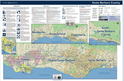
Know where you want to go, but want the most bike-friendly route to get there? Check out the the maps made by SB Traffic Solutions. Below, you will find bike maps of Santa Barbara and surrounding areas. These maps will designate where you will find Santa Barbara bike paths, bike lanes, and other recommended routes.
Maps with Bike Routes
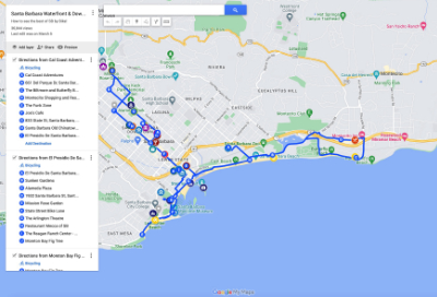
Waterfront & Downtown | 16 Miles |A classic route for a self-guided tour of Santa Barbara's beachfront bike path and downtown area. (Read more about this route below)
Road Bike Maps | Ranging 26-40 Miles |These routes are scenic options for touring Santa Barbara on a road bike, hybrid, or one of our Specialized E-Bikes. The routes vary in difficulty with ranges on mileage and elevation and include portions of road without a bike lane. (Read more about these routes below)
Mountain Bike Maps | Ranging 7-14 Miles |These routes include options for mountain bikers of all levels. Our beginner trails include Ellwood and More Mesa. Our intermediate trails include Tucker's, Eling's, Romero Canyon Fireroad, and Camuesa. Our advanced options include Romero Canyon Singletrack, Jesusita, Cold Springs, and Hot Springs.
Santa Barbara County Bike Path Map (Paper Map Available at our Bike Shop and Downloadable PDFs Below)
Downtown Santa Barbara/Montecito
Garmin Rentals and Files
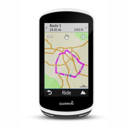
Rent a Garmin with pre-loaded routes for the Santa Barbara County area. Only $20 for 1 day and $5/day for everyday thereafter. To reserve, select "Garmin Edge" when choosing your bike in the checkout process.
If you have your own bike computer, you can access our bike maps using Garmin Connect. Download these gpx files onto your device to view them on the go!

Garmin Connect Files and Route Descriptions
Downtown & Waterfront Garmin Connect File
This route is our go-to suggestion for anyone looking to explore Santa Barbara's oceanfront scenery and downtown features. Riding this route is a great way to get to know the city on any of our bike options. Our goal is to provide you with safe and accessible navigation for you to explore some of Santa Barbara's classic sites. This route starts at our shop and utilizes mostly bike path and roads with bike lanes. It is moderate in mileage and relatively flat in elevation. There is a slight grade as you head up State Street and a short hill if you would like to swing by Butterfly Beach, but overall this is a very mild ride. Whether you are on one of our beach cruisers or an electric bike, you can discover a variety of local gems within a few hours time on this 16 mile route.
Goleta Bike Trail Loop Garmin Connect File
This route is a great option for covering a lot of ground with moderate elevation gain by connecting several of Santa Barbara and Goleta's paved bike paths. Starting from our shop you will take the coastal route through the Mesa and Hope Ranch. Eventually you will hop on the Obern Trail all the way to UCSB Campus. Loop back using the bike lane on Cathedral Oaks and reconnect to the Obern Trail via the Maria Ygnacio bike Path. The bike lane on Modoc and Castillo will take you through downtown towards our shop. Road bikes, hybrids, and Specialized E Bikes are the recommended rental options for this route.
Carpinteria & Goebernador Garmin Connect File
This route sends you East through Montecito, Summerland, and Carpinteria. The bulk of the elevation gain is on the Goebernador climb, which is a winding, shaded country road with no bike lane. Portions of this ride are on small highways. Our road bike rentals are the best option for this route.
Montecito & Hope Ranch Garmin Connect File
This loop provides you with some of the most stunning scenery in the Santa Barbara/Montecito area. The route includes a good amount of climbing, perfect for roadies looking to get a good workout with beautiful views. The largest climb is near the beginning of the route and takes you up to Mountain Drive. After that, you will cut across the mountain range on a winding road with no bike lane. Descend towards the Santa Barbara Mission and take the cross town route to get back to our shop or extend your route to include the rolling hills of Hope Ranch. Hope Ranch is a coastal suburb with smooth roads and an ocean breeze. Overall, it is a beautiful return journey when combined with Mountain Drive, or a serene and shaded ride on its own.
The Ridge Route Garmin Connect File
This route includes the World Class Gibraltar hill climb with an incredible view as you traverse the ridgeline of the Santa Ynez Mountain Range. The ride summits at La Cumbre Peak (~4000 ft). The descent down Painted Cave and Old San Marcos Road is an exhilarating reward, but proceed with caution and stay aware- it's steep and winding. Head back by connecting the Mario Ygnacio bike path with the Obern Trail. Use Modoc for a more direct route into town and back to the shop. Alternatively, you can extend the loop to include the coastal route through Hope Ranch. This route is loaded with elevation gain and includes mountain roads with no bike lane. You will want to prepare with plenty of water and some riding snacks. Our road bike rentals include water bottles, a flat tire repair kit, and a helmet.
Santa Barbara to Ventura
This is a long route with minimal elevation. It utilizes a large portion of bike path running from Bates Road to Emma Wood State Beach. This bike path runs adjacent to the 101 freeway with a view of the ocean and a comfortable sea breeze. This route starts at our shop in Santa Barbara and you will pass through Summerland and Carpinteria on your way to Ventura. The bulk of the elevation is about midway through as you head up Rincon Road.
Hope Ranch Plus Francheschi
This route is sprinkled with smaller climbs all throughout the ride. A combination of coastal views and looking out over the city from the hills. It includes a hidden gem and breathtaking overlook of the city of Santa Barbara- Francheschi Park. This quiet, intimate park is stationed up on the American Riviera. The narrow, windy road to get there has very few cars as it is usually traveled solely by residents. You will definitely recognize it was worth the climb when you stop and take in the view at the top.
Goleta Loop Plus Farren Road
This is one of our longer route options at almost 50 miles long, if you are looking to get a lot of miles without an absurd amount of climbing. You will start with a coastal cruise and utilize several of our favorite bike paths including the brand spankin' new Las Positas Multiuse Path. You will travel to the Goodland (Goleta) and enjoy a gradual country road climb before your halfway turnaround point. This route has a lot of scenic variety: coastal, residential, UCSB campus, rural, and urban. Variety is the spice of life!


